
Standing here and looking out over the valley, you have the same view a Mogollon would have had, centuries ago.
For thousands of years, groups of nomadic people had used these caves to provide temporary shelter. Until, in the late 1200s, some people of the Mogollon culture decided this would be a good place to call home. They built rooms, crafted pottery and raised children in the cliff dwellings for about twenty years. Then the Mogollon moved on, leaving the walls of their homes still standing; offering us a glimpse into their past.
Originally a hunter-gatherer community, the Mogollon people later established farms here in the Gila River valley (in the south of today’s New Mexico), where they grew corn, squash, and beans. To supplement their diet, they hunted mule deer, beaver, elk, and duck; and they foraged for berries and nuts in nearby forest areas.

For safety they chose not to live on the valley floor but high on the cliffs above it. Their dwellings consist of six distinct caves, each of which contained about forty rooms. They used fallen rocks from nearby caves to construct some of these rooms, and also built dividing walls using slabs of conglomerate rock laid with mortar. Many of the walls still stand and retain their original plaster. And all the wooden beams seen in the dwellings are the originals. These ancient builders displayed remarkable engineering skills for their time.
Archaeologists have identified 46 rooms in the six caves, and believe they were occupied by 10 to 15 families. There are also structures used for storage, and signs that some were used for ceremonial purposes. The homes have been dated accurately using the tree rings in those wooden beams. All were built between 1260 and 1280. By around 1300 it is known that the Mogollon had moved out of these homes and abandoned their fields, although the reason is unclear. Maybe drought or other weather conditions meant that life here got too tough. Or maybe they simply fancied a change of scene.
Visiting the cliff dwellings
Today their simple cave-sheltered homes have been preserved and are protected by the National Parks Service. To see them at all you must walk a fairly easy trail from the parking area to a viewpoint. But to get up close, from here you need to follow the more strenuous Cliff Dweller Trail which takes you to the base of the cliff dwellings. What made them special for me was the fact that we could explore inside the caves and buildings*. This made it easier to conjure up images of the people who once lived here and to imagine what their lives must have been like.
*Note that in these Covid-affected times access inside the caves is banned; but you can apparently still climb to the entrances. We were there in 2011 so were able to explore thoroughly.
So come with me on a walk back in time …
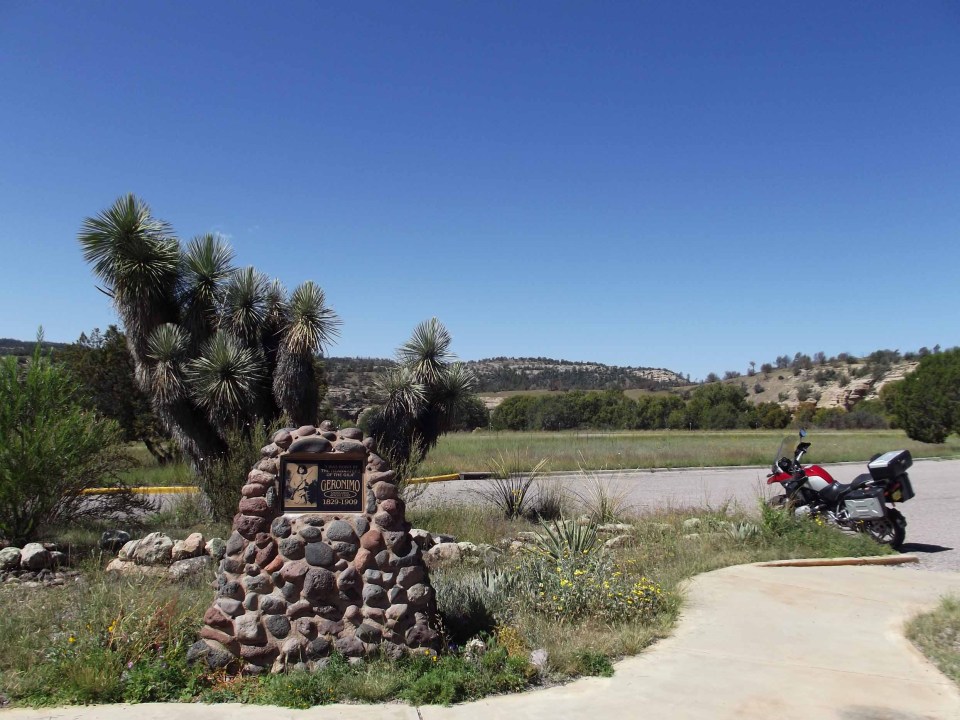
The Visitor Centre
Let’s start here to get our bearings. There are some interesting displays of Mogollon artefacts from the caves and surrounding area, and an exhibit on the Chiricahua Apache who consider this wilderness to be their homeland.
Outside the centre there’s a memorial to Geronimo near the entrance to the parking area. The Chiricahua Apache chief was born very near here (‘By the headwaters of the Gila’, as the monument says). He was one of the fiercest warriors who ever lived; but he didn’t turn to fighting until after the senseless slaughter by Mexican troops of his mother, wife, children, and other tribal women in 1858. During his time as a war chief, Geronimo was notorious for consistently urging raids and war upon first Mexican and later American settlements across Arizona, New Mexico, and Texas. In 1886 he surrendered to U.S. authorities; and the Government moved him and the remaining Chiricahua Apaches out of their homeland. He became a celebrity in later life but was never granted his wish to return to his homeland.
The walk
To get to the trail we must drive a further two miles to another parking lot. As we set out on our walk a ranger gave us a leaflet and explained the walk. He also asked if we were carrying any food or drink; only water is allowed on the trail so everything else has to be left in your car. We had already eaten our lunch at the picnic area near the car park, so were fine to continue.

From the parking lot the path leads across the West Fork of the Gila River, which was largely dried up when we were there (late September). It then follows a tributary stream, Cliff Dweller Creek, on a path that ascends a little, with a few steps in places.


Along Cliff Dweller Creek

So far we found the walk quite easy, although it’s not accessible for anyone with real walking difficulties; we noticed that one elderly lady turned back, leaving her husband to do the walk on his own. The path is mostly shaded and there are glimpses of the cliffs above, although not yet of the caves themselves. Look out for wildlife; we spotted a good-sized lizard, which a ranger later identified for me as a Collared Crevice Spiny Lizard.
After about ¼ mile the path arrives at the viewpoint from where you can get a first glimpse of the cliff dwellings.

This is the point to turn back if you find walking difficult, as the path is about to get a lot steeper. The trail is described as being a mile in length; but we felt that it was probably longer than this, though it’s hard to judge when you’re stopping frequently, as we did. Like us you will want either to catch your breath on the steep parts; and/or to take photos of the fantastic views in places; and/or to explore the interior of these fascinating caves. On the late September day when we were here it was also pretty hot, especially on the long shade-less descent from the caves; so in mid-summer it must be even more so.
I was not, even back then, especially fit or accustomed to hiking, and I had a bad back on our visit; yet I did make it to the top and around the full loop without too much difficulty. The steepest part is that immediately beyond this first viewpoint; a series of steep steps winds upwards until you emerge at the level of the dwellings.

From here it is a more level walk along the face of the cliff to cave one.

Exploring the caves
What makes the Gila Cliff Dwellings special is not their size (several other places, such as Bandelier or Chaco Canyon have bigger groupings). It’s the fact that you can explore inside the caves and buildings; and can do so if you want to on your own. This makes it easier to conjure up images of the people who once lived here and to imagine what their lives must have been like. It was why we deliberately chose to explore on our own, rather than take a guided tour.
Whether exploring alone or in a group, there are six caves that you can get a close look at on this trail; although as four and five are linked it may not feel like that many. The first one is the smallest and has very little in the way of structures; but moving on to cave two we could see some of the original Mogollon constructions. These had already been vandalised when the dwellings were first properly explored by experts; but about 80% of the original structures remained, and the rest have been carefully restored.
There are more structures in cave three, which you need to climb up to. This is where you can really get a sense of the long-ago inhabitants, as you look up at the roof of the cave blackened by soot from their fires; or look out across the valley from its cool interior, as they must have done.


Caves four and five are linked, and I confess that I couldn’t work out exactly where one ended and the next began, even though a helpful ranger whom we met here explained it; the small structure to the right of my photo below, with what appears to be a window, is at the point where cave four becomes cave five. There is apparently a mystery surrounding the purpose of this structure, which is too large to have been a storage area (and in any case has sooty walls) and too small to have been a dwelling. My featured image above was taken looking out from cave five.

Without that helpful ranger we would not have known to climb the ladder propped against one wall in cave five. We would have missed seeing the pictograph painted there by the Mogollon, and the remains of some corn husks on the floor below.

To exit these caves it’s necessary to climb down a wooden ladder of about a dozen steps. This is the longest of the ladders but like all of them is sturdy and stable so should be easy enough to descend. However it was in full sun and the wood had got surprisingly hot; so much so that I could barely hold it!


The trail then leads past cave six, which you can’t enter (right-hand photo above). It then loops around the cliff face before descending steeply to re-join the outward trail just before the bridge.

From here it’s an easy walk back along the valley to where we left our car. I hope you’ve enjoyed the walk and maybe learned a little bit about the Mogollon along the way.
I’m sharing this with Jo on her final (for now at least) Monday Walk. I’ll miss our walks together – see you around Jo!
I visited New Mexico in 2011


25 Comments
Pingback:
Pingback:
rkrontheroad
I have heard of these caves, but have never been. Standing in that space where they lived, one can only imagine what stories are within. I’ve been to Mesa Verde many times and hope you get there, and seen petroglyphs elsewhere in New Mexico.
Sarah Wilkie
I’d love to visit Mesa Verde one day Ruth! We saw petroglyphs at Bandelier – is that where you’ve seen them? But I didn’t see any pictographs there so seeing this one was pretty special 🙂
rkrontheroad
The petroglyphs weren’t in any identified place. They were along a north-south side road on the way from Santa Fe to Colorado. Some locals told me about them and it was quite a find!
Sarah Wilkie
Wow, that was a bit of luck! I wish we’d known about them as we were in and around that area for several days.
starship VT
Another interesting post, Sarah. The Gila Cliff Dwellings remind me of Mesa Verde National Park in Colorado although there are differences. We visited there many years ago when taking a side trip from visiting my in-laws who lived near the entrance to Rocky Mountain National Park. Your posts on your travels in New Mexico keep my hope alive of visiting that state sometime in the future.
Sarah Wilkie
Thank you Sylvia 🙂 Yes, I believe there are similarities with Mesa Verde (somewhere I would love to visit btw). I’m sure you’d enjoy NM if you get to go, it’s got something for everyone!
Marie
All new to me and very enjoyable. We’ve been to Sante Fe and Albuquerque but the region has so much more to offer – hopefully we’ll get back there some day…. XXMarie
Sarah Wilkie
Glad you enjoyed this Marie. There’s plenty to see in the south of New Mexico if you’re ever back that way again 🙂
thehungrytravellers.blog
Hi Sarah, we hadn’t heard of the Mogollen before. Very interesting post, it is fascinating how people lived in such places, would love to see these caves, particularly if they open them up again once this pandemic is over. Cave houses and temples are very interesting.
Sarah Wilkie
I hadn’t heard of them either until I started researching this road trip. This was a fascinating visit but I would wait until you can go inside the caves again before going there as from the outside you can’t really appreciate the work that went into the structures nor can you get that sense of what it must have been like to live there.
Nancy Gordon
Wow I’ve never been to this part of New Mexico. I loved your pictures and commentary as always. After reading this I’d like to have a tour of the Mogollon Cliff Dwellings and learn more about the people who lived there.
Sarah Wilkie
Thanks Nancy 😀 This is a lovely part of the state with some pretty scenic byways to explore and a couple of cute towns. We stayed in Silver City the night before coming here and really liked it, and Hillsboro was lovely too. Highly recommended!
wetanddustyroads
I’ve never heard of the Mogollon and found your post very interesting, thanks Sarah.
I would love to explore these caves (and the views you had, was beautiful). I particularly liked the pictograph. In the Cederberg mountains close to us, there are many caves with these pictures on the walls (we just call them rock art).
Sarah Wilkie
Thank you – I’m glad you found this interesting and informative 🙂 A pictograph is one form of rock art, using pigments to paint on the rock, but you can also find petroglyphs, where the design is carved into the rock – another form of rock art. I find the latter even more fascinating for some reason!
wetanddustyroads
Oh yes, on one of our road trips last year, we’ve seen some huge rocks with petroglyphs and I found it very interesting.
mtncorg
Gila Cliff also demonstrates the wide spread of the cliff culture with fewer crowds in a beautiful area of New Mexico.
Sarah Wilkie
Thanks Mark – we loved NM and found it pretty uncrowded except in the most famous destinations like Santa Fe. Certainly around here there were relatively few visitors although I couldn’t say we had the place to ourselves. There was a small tour group (about six people) and several other couples – and that was it 🙂
maristravels
I would have turned back at the sign that said Rattlesnakes sighted! I am not brave when it comes to snakes, crocodiles, bears, lions, tigers and other species that don’t like me. You did well to see so much and do so much walking/climbing. Great post.
Sarah Wilkie
I can see it could be off-putting but there are rattlers all over the US South West and if you travel there you’d have to stay in your car to avoid all such signs! They shouldn’t be a problem if you stay on the open paths and watch where you’re walking – they would only attack (apparently) if trodden on or otherwise disturbed. In several trips to that region we’ve never seen one although I have heard them rattle in the undergrowth occasionally.
leightontravels
Seeing that lone pictograph must have been pretty special. Only that one exists in the entire location, right?
Sarah Wilkie
I don’t know to be honest – it’s the only one we saw but as we had to have it pointed out to us, there could be others hidden away that we also missed. But the site isn’t famous for them so there must be relatively few.
restlessjo
The only Indians I could name are Geronimo and Sitting Bull, so it’s interesting to see where one of them lived. He terrified me in the movies as a child, but if somebody had killed my family i think I might be a bit violent too.
Many thanks, Sarah! I hope to come back smiling 🙂 🙂 Have a good summer!
Sarah Wilkie
Thanks Jo – you have a good and restful summer too!